FULL DAY KAYAK WITH WHALES
IN THE FRANCISCO COLOANE MARINE PARK
Sail next to the whales, between the fjords and the glaciers in the Strait of Magellan. A luxury adventure in the Francisco Coloane Marine Park. Nature, adventure, comfort and contemplation.
Your post in the most pristine and wild place on the planet.


Transformational Journeys, of experiences in nature.
After your exploration, you do not return the same.
$795 USD per person
Description
03:45 am The adventure begins with the pick-up and check-in at the travel agency. then we take a transfer to the port of embarkation for 45 min.
05.15 am Sailing in a Catamaran, from Bahía Carrera to the Marine Park, a journey of approximately 3 hours to the place of the whales. along the way historical and geographical places of great beauty. Evergreen mountains and islands are part of the landscape, it is also possible to see many birds, colonies of dolphins and sea lions. Already in the marine park, we take the kayaks and sail with the whales. a safety briefing and navigation plan are part of the tour.
Itinerary
03:45 Check in at the hotel. transfer to travel agency.
04:05 Transfer to the boarding place, 45 km south of Punta Arenas.
04:20 Boarding at Carrera Bay
05:15 Start of Navigation. Passed by different points of attraction
_ Fuerte Bulnes
_ San Isidro Lighthouse
_ Mount Tarn
_ Indio Bay
_ Cape Froward
_ Cape Holland
_ Rupert Island
_ Carlos III Island
_ Charles Islands
_ Shag Passage
08:00 Entrance to the Marine Park
08:30 Watching Penguins, from the deck of the boat.
09:00 Navigation from Rupert Island to Charles Islands and Shag Pass.
10:00 Landing of the Catamaran to the zodiac boat, to do, kayak with Whales. (3 hours app)
13:00 Boarding from the zodiac boats to the Catamaran
14:00 Lunch
17:00 Disembarkation of the Catamaran and transfer to Punta Arenas
18:00 pm we will be in Punta Arenas.
Includes
Briefing the previous day online or in person, transfer / Marine fauna guide (Spanish / English) / All meals / Accident insurance / Navigation and safety clothing.
Sail alongside the whales, between the fjords and glaciers in the Strait of Magellan. A luxury adventure in the Francisco Coloane Marine Park. Nature, adventure, comfort and contemplation.
Kayak Agua Fresca invites you to live this incredible experience that you will treasure for the rest of your life. This is an incredible opportunity to experience one of the last untouched natural areas in the world. We invite you to follow the ancient canoe routes, where the “kawésqar” indigenous people once navigated. In our adventures we provide educational values about local cultural heritage, information about historical journeys, and we promote the conservation of biodiversity, among others.
The adventure begins with pick-up at accommodation and check-in at the travel agency. Then, we take a transfer to the port of embarkation, for 45 minutes.
Catamaran sailing, from Bahía Carrera to the Marine Park. A trip of approximately 3 hours to the whale site. Along the way, you can see historical and geographical places of great beauty, evergreen mountains and islands are part of the landscape. It is also possible to see many birds, colonies of dolphins and sea lions.
Navigation
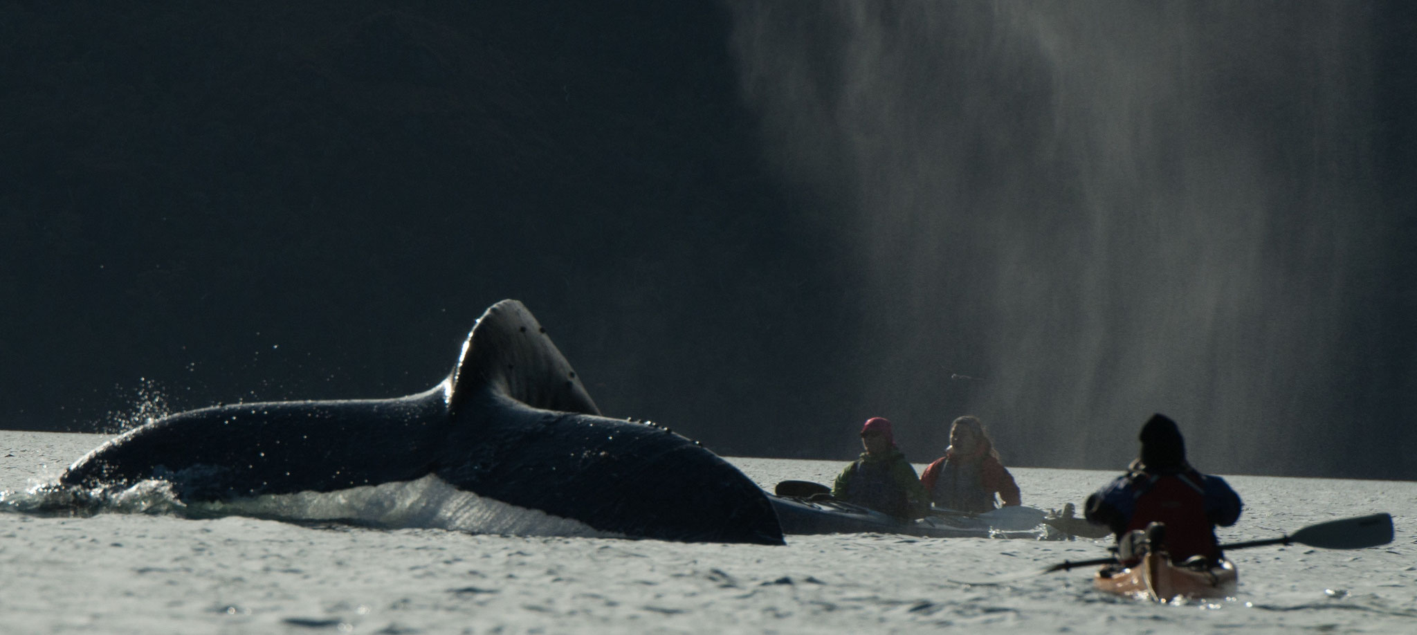
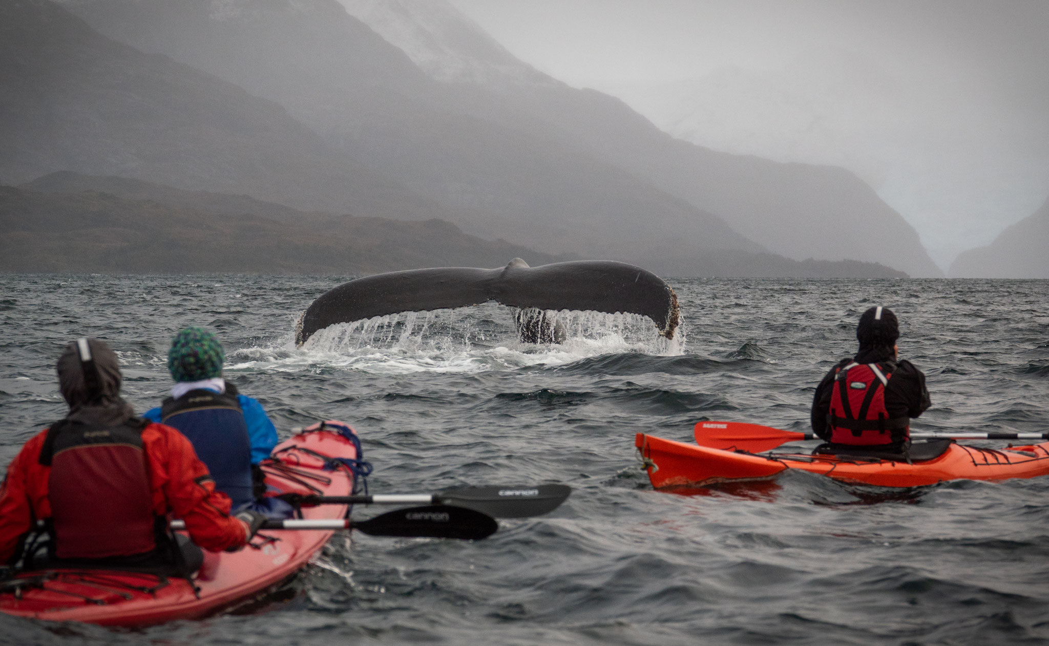
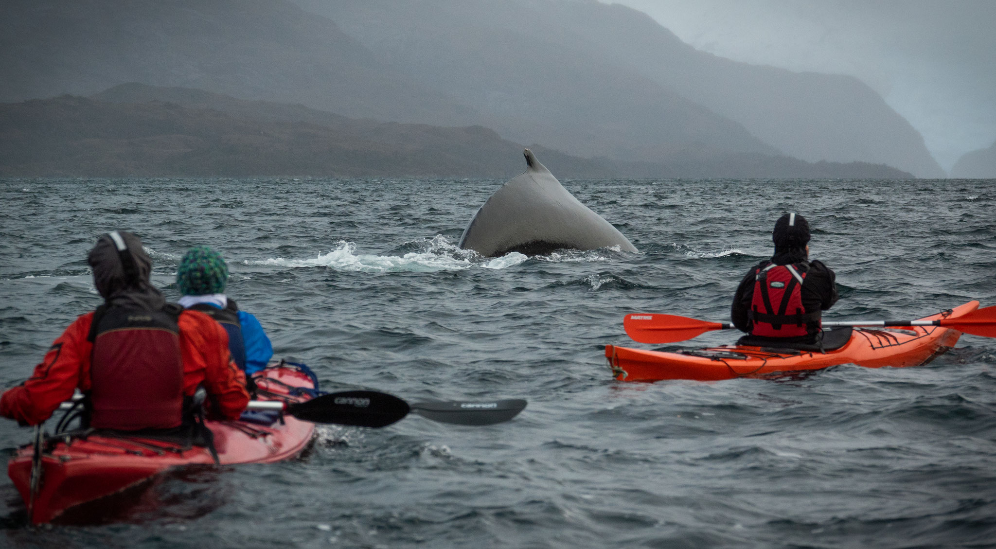
This excursion is designed for real adventurers and nature's lovers. Kayak through incredible locations from the comfort of our stable double sea kayaks. We will visit spectacular feeding grounds of Humpback Whales. This experience will leave you feeling like a true explorer as we paddle in one of the last untouched regions of the world. We will enjoy another adventure, traditional chilean meals with exquisite wine. Now it's a great time to share our stories and experiences from the day. You don't need to be an expert sea kayaker, our guides will share with you professional instruction to insure safety and allow you to develop your paddling skils.
Recommendations
Considering the rough weather conditions of the zone, we recommend you to dress in layers. You should wear a base Layer made of merino wool or synthetic fabrics. Remember this is your next-to-skin layer. It helps regulate your body temperature by moving perspiration away from your skin. A middle layer (insulating layer) helps you retain heat by trapping air close to your body. Micro-fleeces, merino wool tops, soft shells and insulated jackets are some middle layers. And an outer layer that protects you from the wind and rain. You should also bring a warm beanie or a bandana, some warm gloves and comfortable shoes.
Departure Calendar 2024-2025
December 2024: 3, 7, 10, 14, 17, 21, 24, 28, 31.
January 2025: 4, 7, 11, 14, 18, 21, 25, 28.
February 2025: 1, 4, 8, 11, 15, 18, 22, 25.
March 2025: 1, 4, 8, 11, 15, 18, 22, 25, 29.
To reserve, send from each person: cristiankayakaguafresca@gmail.com
- Full name
- Passport number or RUT
- Nationality
- Birthdate
- Size (S-M-L-XL)
- Shoe Number
- Food restriction
- Important medical condition
- Accommodation
- Cell phone number
- Emergency contact
It includes
• Private transfer to and from Punta Arenas (boarding place)
• Marine fauna guide aboard (Spanish / English)
• Kayak exploration guide
• All meals, (breakfast, lunch and celebration snack)
• Travel assistance insurance
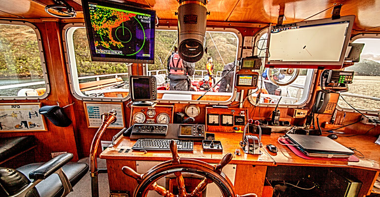
Our mothership
_ 80 comfortable seats, distributed in a first and second level. 14 space passenger kayaking
_ This boat has a cruising speed of 20 knots and a cafeteria on board.
_ It has a service crew and expert exploration guides.
Route map and its attractions points
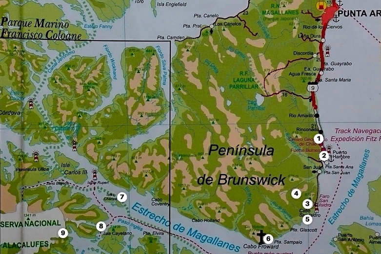
Interest Point
1 CARRERA BAY
Located 50 km south of Punta Arenas, near from Bulnes Fort. It is known as an important port of shipment in the city of Punta Arenas.
2 BULNES FORT
In May, 1843 the schooner “Ancud” set sail from Ancud, Chiloé Island, in command of Captain John Williams. After 4 long months of sailing, the schooner “Ancud” anchored outside “Hunger Port” on September 21st. Captain Williams took possession of the Strait of Magellan and its territory. In this place was founded a fort named “Bulnes”, in tribute to the current president “Manuel Bulnes”.
3 CAPE SAN ISIDRO
San Isidro Lighthouse is the southern most habitable lighthouse of the American continent. It has more than 100 years of history that are part of the cultural heritage of the zone. Pristine environment surrounded by sub-antarctic forests and marine wildlife such as the Peale's Dolphin, an endemic species of Southern South America. It is also possible to find Sea Lions and South American Fur Seals.
4 MOUNT TARN
Charles Darwin was one of the first explorers in the ascent “Mount Tarn” in 1834. He visited “The Strait of Magellan” and sailed aboard the famous English ship “The HMS Beagle" commanded by the Captain Fitz Roy during the 19th century. Darwin discovered the first ammonites that has been ever found in South America. Ammonites are ancient cephalopod molluscs with rolled outer shells and bilateral symmetry.
5 ÁGUILA BAY
Águila Bay is located 75 km south of Punta Arenas, at the beginning of the southeast coast of Brunswick peninsula. There was the first plant for storage and treatment of whale oil. There were important facilities for industrial slaughtering of cetaceans. In the active period of whaling they almost exterminated the species reaching a number of 30 cetaceans. Nowadays, there are approx. 240 whales remaining in the Magallanes Region.
6 CAPE FROWARD
Located 90 km south of Punta Arenas. In this place is the famous “Cross of the seas” in tribute to all the brave sailors that have sailed this rough waters. Cape “Froward” was named by the English corsair Thomas Cavendish, in due to his many attempts to sail this waters. Froward means: difficult to deal with.
7 FRANCISCO COLOANE MARINE PARK
Created in 2003. Located in Magallanes region, in the Strait of Magellan between Santa Ines and Riesco Islands. The Park was created because it is part of a very important biological corridor, being the habitat of the famous Humpback Whale and here is possible to see whales during their feeding season.
8 SHAG PASS
The Shag Pass is located within the protected area of Francisco coloane Marine Park, between Cayetano and Santa Inés Islands. It is a place that has a great concentration of Humpback Whales and it is an essential point in our navigation.
9 SARMIENTO GLACIER
A HUGE SUB-ANTARCTIC ECOSYSTEM
This is a tempered-cold glacier, it is sometimes very rainy and it use to suffer frosts. It belongs to the mountain range of the southern Patagonian Andes. The area is surrounded by dense sub-antarctic Nothofagus forests. There are also many islets and rocks covered with mosses and lichens, charactheristic of the sub-antarctic ecosystems. The marine ecosystem is determined by feeders and the convergence of migratory currents of many marine mammals and birds.
Why Whales come to Patagonia
Humpback whales (Megaptera novaeangliae) undertake seasonal migration between productive high-latitude areas where they feed in summer and low-latitude tropical waters where mating and calving occur during winter. In the eastern south Pacific, the species breeds off Colombia and Ecuador, and feeds primarily in the western Antarctic Peninsula and in the waters of the Strait of Magellan, like feeding ground for humpback whales. The duration of the whale's trip between these migratory destinations is 88 and 99 days. The humpback whale enters the channels of the Strait of Magellan and stayed there for almost five months to eat and rest.
Sub Antartic Forests
The southernmost forests in the world grow in Magellanic Chile, where forest species extend their range to within about 500 miles of Antarctica. The Subantartic Magellanic Evergreen Rainforest Ecoregion runs along the western margin of southern South America, extending from Penas gulf (48°S) to Cape Hornos (56° S). The distribution of this Ecoregion is correlated with an oceanic microthermal temperature regime and high, constant precipitation.
The vegetation shows principally two types of forest, mainly evergreen "Nothofagus betuloides" forests to the west and deciduous "Nothofagus pumilio" and "Nothofagus antarctica" forests towards the east. This forests are pretty old, some specimens of Nothofagus betuloides are probably 1500–2000 years. There are other species like "Pilgerodendron uviferum" and "Podocarpus nubigena" that may reach ages of ⩽1000 years. Even some of the small understory trees are probably several hundred years old. Its varied and majestic landscapes that include high mountain peaks, enormous icefields, and innumerable fjords are inhabited by endemic animal and plant species. Glaciers and icefields predominate toward the Andean mountains zone, while moorland and Tundra formation prevail toward the Pacific Ocean border. You can also find miniature forests covering the rocks and soil of the tundra formations along the coast and alpine zones with a diversity of lichen and moss species. This Tundra formations are characterized by prostate dwarf shrubs, cushion plants, grass-like plants and bryophytes on water-logged terrain that in different combinations form vegetation of scrub or bogs. The bogs comprise characteristic austral species such as Astelia, Bolax, Caltha, Donatia, Drapetes, Gaimardia, Phyllachne and Lepidothamnus.
Ancestral Canoe Routes
In this adventure you are going to navigate some of the canoe routes where Kawésqar native people used to move hundreds of years ago. As one of the Southern-Chilean Canoe Tribes, the Kawésqar lived a nomadic life, paddling the archipelago's channels in their canoes moving from island to island in search of food. It is said that they even carried their canoes short distances over land to avoid unnecessary sea trips. They used to navigate an extended territory from the Gulf of Penas roughly to the Strait of Magellan as far as the southern end of the Sarmiento Channel. Their canoes could hold a family of up to ten people. The family traveled with its dogs, weapons and tools, and the leather sheet that was used as a tarp at campsites. an unique experience in remote rough waters
Some routes Kawésqar used to navigate and we may also navigate are the following
_ San Nicolás Bay - Bouchage Bay
_ Charles Islands - Shag Pass
_ Bachelor River - Rupert Islands
_ Cape San Isidro - San Nicolas Bay.
+569 4093 6932
https://kafnorth.com
La Serena, IV Región, Chile

+56 9 54112369
cristiankayakaguafresca@gmail.com
21 de Mayo 1342
Punta Arenas, Chile
PATAGONIA